The Wilderness Project is dedicated to exploring, researching, and
enhancing the protection of 1.2 million square kilometers of Africa's
invaluable wilderness areas.


Learn More

THE GOALS

1.2 million

square kilometers of land
under strengthened
conservation efforts

6

major river
basins explored, studied,
and documented
 

480 million

Freshwater supply
maintained for
people

THE VISION

By 2035, The Wilderness Project plans
to collaborate with local communities
, governments, researchers, and NGOs
to explore, study, and enhance the
protection of 1.2 million square
kilometers of Africa’s invaluable
wilderness. A key focus of this initiative
is to establish comprehensive baselines
for the largely undocumented sources
and watersheds of Africa’s most
significant river basins—Okavango,
Zambezi, Congo, Nile, Chad, and Niger.
This will be achieved by tracing the
Great Spine of Africa (GSoA), which
connects the water towers sustaining
sub-Saharan Africa.

THE URGENCY

From their sources to their final

destinations in deltas and swamps,

these six major river basins are vital not

only for supporting some of the planet’s

most biodiverse ecosystems but also for

providing drinking water and irrigation

to over 400 million people. Despite

their significance, these river systems

have long been undervalued, neglected,

and exploited for the gain of outsiders.

Africa’s last wild rivers now face severe

threats from rapid, unsustainable

development, including deforestation,

mining, fires, pollution, and damconstruction.

The inaccessibility and
remoteness of the Great Spine have left
a significant gap in scientific data,

which is crucial for defending against

the catastrophic impacts of climate change.

DR. STEVE BOYES

"In science, we pursue truth and understanding.
In storytelling, we strive for impact and significance."

HOW WE DO IT

Research Expeditions

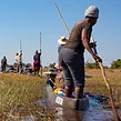
With the help of mekoro and canoes, we have traversed and explored more than 16,000 kilometers of Africa's most remote river landscapes. Over the next decade, we plan to survey an additional 45,000 kilometers, employing a variety of standard research techniques. By utilizing technologies like satellite imagery and AI, we gather data to evaluate the health of rivers within specific systems, across entire basins, and over time. This approach allows us to create a River Health Index, which can influence immediate actions, shape long-term policies, and support community-based conservation efforts.

Community Programs

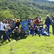
Our conservation efforts rely heavily on the support of local communities. These communities serve as our local experts, possessing cultural traditions shaped by the rivers they depend on and a deep understanding essential for protecting wild areas. We collaborate closely with them to support sustainable livelihoods and enterprises that align with their environment. To achieve this, we continually seek out and partner with local organizations and entities that can work with us across various sectors.

Storytelling

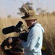
Creating top-tier documentaries, podcasts, and other conservation media is essential to advancing our long-term goal of building momentum for stronger environmental protection. By sharing the science, as well as the histories and cultures of local communities, we strive to highlight the opportunities and challenges present in these remote and often underappreciated wilderness areas. A crucial part of this mission is developing a network of local storytellers who can offer media from deeply localized and frequently overlooked perspectives.

SPONSORS &
PARTNERS